Horse Trails
Horse Trails
Dry Creek Equestrian Trailhead - TrailMeister added this area
Calhoun, GA
Riders have logged 6.36 miles & 2.27 hours here.
TOP TRAIL RIDER: kbaker logged 6.36 miles.
 Printable Map
-
 Directions
×
Directions
×Driving Directions
Click the icon for directions in google.Take Exit 320 on I-75; follow State Highway 136 west about 14 miles to Villanow, Ga. At the intersection with Highway 201, turn left onto East Armuchee Road (County Road 705) and go about 7 miles. Just past the signed Manning Mill Road, turn left onto Forest Road 226 and follow the signs to the Dry Creek Trailhead.
-

- ★★★★★
 Printable Map
-
 Directions
×
Directions
×Driving Directions
Click the icon for directions in google.Take Exit 320 on I-75; follow State Highway 136 west about 14 miles to Villanow, Ga. At the intersection with Highway 201, turn left onto East Armuchee Road (County Road 705) and go about 7 miles. Just past the signed Manning Mill Road, turn left onto Forest Road 226 and follow the signs to the Dry Creek Trailhead.
- ★★★★★

string(64) "https://trailmeister.com/wp-content/uploads/2014/01/drycreek.jpg"

string(65) "https://trailmeister.com/wp-content/uploads/2014/01/drycreek1.jpg"

string(65) "https://trailmeister.com/wp-content/uploads/2014/01/drycreek2.jpg"

string(65) "https://trailmeister.com/wp-content/uploads/2014/01/drycreek3.jpg"

Rides Add Your Ride
| Date | Rider | Hours | Minutes | Miles | GPS | Photos | Rating | |
|---|---|---|---|---|---|---|---|---|
| 28 Nov 2020 | kbaker | Ride Notes | 2 h | 16m | 6.36 | ✔ | ★★★★★ |
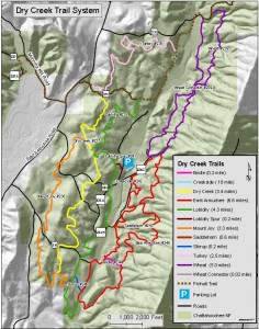
The US Forest Service refers to the Dry Creek Trail system as 26 miles of horseback riding awesomeness. For good reason!
- Land Manager is Chattahoochee-Oconee National Forest
- Coggins test is required. Please bring your papers with you.
Like our content?
Then you’ll love our newsletter.
New horse camps and trailheads, gear reviews, tips, videos, inspiring stories and more.


