Horse Trails
Horse Trails
White Horse Campground Loop - djfoster39 added this area
Meadow Valley, CA
 Printable Map
-
 Directions
×
Directions
×Driving Directions
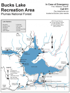
Click the icon for directions in google.From Hwy 70 in Oroville, take Hwy 162 east about 50 miles. Turn left at Haskins Valley and follow the road past the resort area around the south shore of the lake about 2 miles. When you cross the bridge over Bucks Creek watch for the entrance to the campground on the right. The camp host will guide you to sites 16,17, and 18 - the ones reserved for equestrians.
-

- ☆☆☆☆☆
 Printable Map
-
 Directions
×
Directions
×Driving Directions
Click the icon for directions in google.From Hwy 70 in Oroville, take Hwy 162 east about 50 miles. Turn left at Haskins Valley and follow the road past the resort area around the south shore of the lake about 2 miles. When you cross the bridge over Bucks Creek watch for the entrance to the campground on the right. The camp host will guide you to sites 16,17, and 18 - the ones reserved for equestrians.
- ☆☆☆☆☆
No Rides Found Be the first to Add Your Ride
White Horse Campground has just opened 3 sites to equestrian use. The loop trail goes east to meet a feeder trail connecting to the Pacific Crest Trail at Bucks Summit. Riders looking for an easy 5 mile ride can just ride the loop, or if they want a challenge, they can ride north on the PCT up to the Spanish Peak trail for a fabulous view, and then turn around and return to camp via the Right Hand Branch of the Mill Creek trail, continuing to the left along the Mill Creek trail on the east shore of Bucks Lake. This is a strenuous 18 to 20 mile loop with some rather difficult creek crossings. The scenery is outstanding. This trail is primarily wilderness area so there will be no bicycles.
- Land manager is Plumas National Forest (530) 534-6500
Quincy Ranger District (530) 283-0555 - Fee area
Like our content?
Then you’ll love our newsletter.
New horse camps and trailheads, gear reviews, tips, videos, inspiring stories and more.


