Horse Trails
Horse Trails
White Bluffs Recreational Area - caroleschuh added this area
Othello, WA
Riders have logged 14.16 miles & 5.62 hours here.
TOP TRAIL RIDER: caroleschuh logged 14.16 miles.
-
 Directions
×
Directions
×Driving Directions
Click the icon for directions in google.For the north trailhead, drive to Othello from the Tri Cities. At the junction of Hwy 26 and Hwy 24, turn south on Hwy 24. Just before milepost 63 turn left at the gated entrance to the Wahluke Unit of the Hanford Reach National Monument. Follow this road for eight miles to the trailhead. For the south trailhead: From I-182, take the Road 68 exit from Pasco and head north on Road 68 until it turns into Taylor Flats. Follow Taylor Flats and take a left after the road ends on Ringold Road. Follow it for a few miles until you reach a sign that instructs you to turn left towards Ringold. Once at Ringold follow the gravel road north until you reach a sign that says no automobiles. From Ellensburg, drive east on Interstate 90 to Vantage and across the Columbia River. Immediately after crossing the river, turn right (south) at exit 137 onto State Route 26 and continue 0.9 mile to a junction with SR 243. Turn right onto SR 243 and drive 14.3 miles, then turn left (east) onto the Mattawa Highway/SR 24 Cutoff Road (signed as \"24SW\"). Drive 13.8 miles along this straight road to its junction with SR 24. Turn left onto SR 24. Just past milepost 63, turn right onto the dirt road signed \"Wahluke National Wildlife Refuge\" and guarded with a huge solar-powered gate system, which closes at night. Drive 4 miles to a 4-way intersection, then turn right towards White Bluffs Landing which a sign indicates. Continue 1.4 miles to White Bluffs Landing where the faint hiking trail is visible to the North. Alternatively, driving straight for an additional 4 miles from the 4-way intersection on slightly rougher gravel road to a scenic view point. Washington Department of Fish and Wildlife permit required.
-

- ☆☆☆☆☆
-
Directions
×
Driving Directions
Click the icon for directions in google.For the north trailhead, drive to Othello from the Tri Cities. At the junction of Hwy 26 and Hwy 24, turn south on Hwy 24. Just before milepost 63 turn left at the gated entrance to the Wahluke Unit of the Hanford Reach National Monument. Follow this road for eight miles to the trailhead. For the south trailhead: From I-182, take the Road 68 exit from Pasco and head north on Road 68 until it turns into Taylor Flats. Follow Taylor Flats and take a left after the road ends on Ringold Road. Follow it for a few miles until you reach a sign that instructs you to turn left towards Ringold. Once at Ringold follow the gravel road north until you reach a sign that says no automobiles. From Ellensburg, drive east on Interstate 90 to Vantage and across the Columbia River. Immediately after crossing the river, turn right (south) at exit 137 onto State Route 26 and continue 0.9 mile to a junction with SR 243. Turn right onto SR 243 and drive 14.3 miles, then turn left (east) onto the Mattawa Highway/SR 24 Cutoff Road (signed as \"24SW\"). Drive 13.8 miles along this straight road to its junction with SR 24. Turn left onto SR 24. Just past milepost 63, turn right onto the dirt road signed \"Wahluke National Wildlife Refuge\" and guarded with a huge solar-powered gate system, which closes at night. Drive 4 miles to a 4-way intersection, then turn right towards White Bluffs Landing which a sign indicates. Continue 1.4 miles to White Bluffs Landing where the faint hiking trail is visible to the North. Alternatively, driving straight for an additional 4 miles from the 4-way intersection on slightly rougher gravel road to a scenic view point. Washington Department of Fish and Wildlife permit required.
- ☆☆☆☆☆


Rides Add Your Ride
| Date | Rider | Hours | Minutes | Miles | GPS | Photos | Rating | |
|---|---|---|---|---|---|---|---|---|
| 30 Mar 2016 | caroleschuh | Ride Notes | 3 h | 16m | 7.49 | ✔ | ✔ | ☆☆☆☆☆ |
| 22 Mar 2016 | caroleschuh | Ride Notes | 2 h | 21m | 6.67 | ✔ | ✔ | ☆☆☆☆☆ |
White Bluffs was an agricultural town in Benton County, Washington. It was depopulated in 1943 along with the town of Hanford to make room for the nuclear production facility known as the Hanford Site.
Prior to the arrival of white settlers, the land was inhabited by the Wanapum Indians, a tribe closely related to the Palouse, Yakama, and Nez Perce tribes.
The first white settlement at White Bluffs was in 1861. The original townsite was located on the east bank of the Columbia River in Franklin County. A ferry was built to accommodate traffic across the Columbia headed for the gold rush in British Columbia. By the early 1890s the population had grown and the town expanded to the west bank of the Columbia in Benton County.
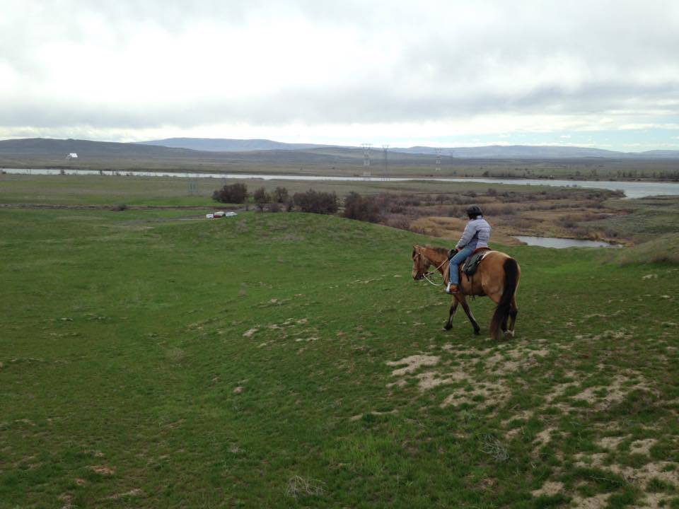
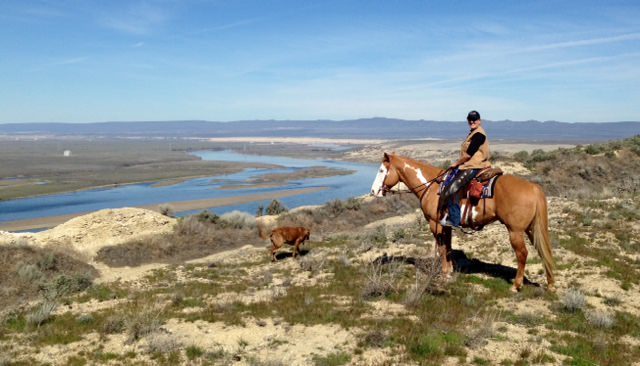
North Slope – The Hanford Reach can be seen from the long stretch of the White Bluffs. Wildlife makes full use of this pristine stretch of river and surrounding native lands. Look for horned lizards sunning themselves on the rocks and big rafts of waterfowl on the free-flowing river. On a recent winter day, we spotted more than a thousand Canada geese on the river, with scores of tundra swans resting on the sandy islands dotting the river.
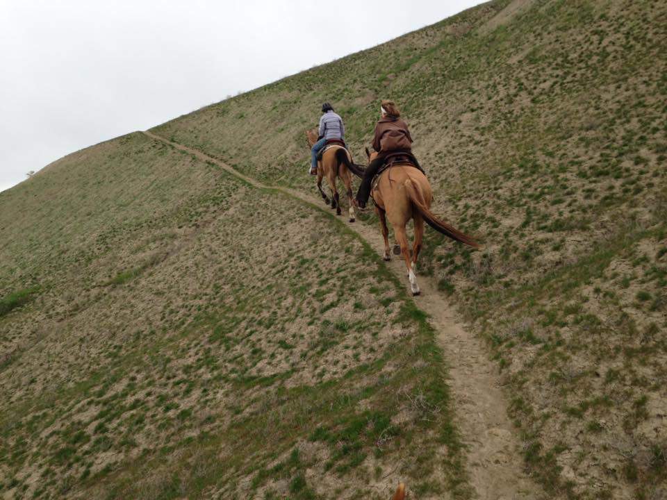
Heading north from the parking area, you’ll find a remarkable desert trek along the White Bluffs, just across the river from the still heavily restricted Hanford Nuclear Reservation managed by the U.S. Department of Energy.
South Slope – The White Bluffs of the Hanford Reach National Monument offer a unique riding experience in the shrub-steppe. Instead of the usual cliffs and boulders of basalt, this area features bluffs and badlands of the Ringold Formation, ancient river and lakebed sediments laid down by the Columbia River system.
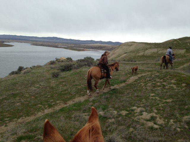
The south section of the White Bluffs in particular contains so many possible routes and variations that it would take numerous visits to explore them all. On this hike you’ll drop down through the bluffs and ride along the last free-flowing stretch of the Columbia River, climb to a ridge and ride with panoramic views, and perhaps visit the sandstone pillar. You’ll likely see flocks of water birds, tracks of the myriad denizens of the shrub-steppe, and, if you’re here in the evening, hear the songs of coyotes.
The trail begins atop the bluffs at the White Bluffs Overlook with its sweeping view of the entire White Bluffs – Hanford Reach area. To begin your ride, walk around the gate and follow the old paved Ringold Road as it descends the bluffs. Watch for ripple patterns and multi-hued depositional layers in the cliffs beside the roadway. This is one of the best and most accessible exposures of the Ringold Formation to be found anywhere.
After about a mile the road crosses a bench and then descends to river level through a large cut. Follow the road below towering bluffs until you’re a couple of hundred yards from the power lines (approximately two and three-quarter miles from the trailhead), then head left across the flats to the trail that climbs into the broad saddle in the low ridge about 100 yards away. If you continue ahead on the pavement, in less than a quarter mile you’ll come to a gate across the road and the south trailhead, easily accessible from the Tri-Cities via Taylor Flat and Ringold Roads.
From the saddle go straight ahead on the obvious trail that climbs into a saddle in the higher ridge beyond. Here is a spectacular view across what some call the Great Valley to even higher bluffs. At this point you have a number of options. You can turn right and follow the trail southeast along the crest of the ridge to the high point just beyond the power lines, then drop into the valley for a mile or so of easy riding beneath 300 – 500 foot cliffs and badlands.
A second option is to follow the trail that traverses from the saddle into the valley. Or, you can turn left and follow the trail northwest along crest of the ridge to another high point. This makes a great lunch spot. After soaking up the views, continue along the ridge crest, gradually descending to the northwest end of the Great Valley, and then follow the trail as it traverses below the bluffs back to Ringold Road where the road crosses the bench. If you have time, you can easily combine the ridge ride with a tour of the valley.
Once back on Ringold Road, it’s short mile back to the trailhead, but if you want a little more, continue across the road to a fainter trail leading to the obvious sandstone pillar above the river. The area around the pillar is very hummocky (evidence of an ancient landslide) with many game trails providing lots of interesting terrain to explore.
When you’ve had your fill, make your way back to Ringold Road and climb the final half-mile or so back to the trailhead and the conclusion of another scenic ride in the shrub-steppe.
Many thanks to TrailMeister use Caroleschuh for sharing this fabulous horse riding area!
Land manger is Washington Department of Fish and Wildlife
Please obey all signs and directions. Do not cross the Columbia River to the Hanford site. Do not cross the posted fences to the far north.
Discover pass is required