Submit a Trail
Horse Trails
Horse Trails
Poosey Conservation Area - TrailMeister added this area
Trenton, MO
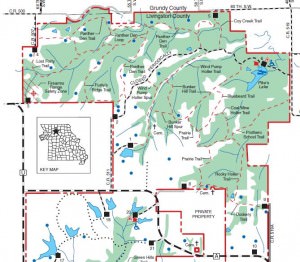
 Printable Map
-
 Directions
×
Directions
×Driving Directions
Click the icon for directions in google.Poosey Conservation Area is in northwest Livingston County, six miles southeast of Jamesport, nine miles northeast of Lock Springs, 12 miles southwest of Trenton and 13 miles northwest of Chillicothe.
-

- ☆☆☆☆☆
 Printable Map
-
 Directions
×
Directions
×Driving Directions
Click the icon for directions in google.Poosey Conservation Area is in northwest Livingston County, six miles southeast of Jamesport, nine miles northeast of Lock Springs, 12 miles southwest of Trenton and 13 miles northwest of Chillicothe.
- ☆☆☆☆☆
No Rides Found Be the first to Add Your Ride
The northern half of the Poosey Conservation Area has a 20-mile network of trails and service roads that are open to equestrian use.
- Land Manager is Conservation Commission of Missouri
- All trails within the Poosey Conservation Area are closed during firearms deer season.
- Day Use Only
Like our content?
Then you’ll love our newsletter.
New horse camps and trailheads, gear reviews, tips, videos, inspiring stories and more.


