Horse Trails
Horse Trails
New Fork Trailhead - 1trailmeister added this area
Pinedale, WY
-
 Directions
×
Directions
×Driving Directions
Click the icon for directions in google.Starting from the Town of Pinedale, Wyoming, head west on United States Highway 191 (US-191) for 6 miles, then make a right turn onto Wyoming State Highway 352 (WY-352) towards Cora. Follow WY-352 for about 14.4 miles, and bear right at the fork to get onto New Fork Lake Road/County Road-162 (CR-162). Follow CR-162 for about 3 miles, and then the road name changes to New Fork Lake/Forest Service Road-370730 (FS-370730) upon entering the Bridger-Teton National Forest. Follow FS-370730 for 3 miles to the end of the road and New Fork Trailhead is on the left. Approximate travel details from the Town of Pinedale: 26 miles, 40 minutes.
-

- ☆☆☆☆☆
-
 Directions
×
Directions
×Driving Directions
Click the icon for directions in google.Starting from the Town of Pinedale, Wyoming, head west on United States Highway 191 (US-191) for 6 miles, then make a right turn onto Wyoming State Highway 352 (WY-352) towards Cora. Follow WY-352 for about 14.4 miles, and bear right at the fork to get onto New Fork Lake Road/County Road-162 (CR-162). Follow CR-162 for about 3 miles, and then the road name changes to New Fork Lake/Forest Service Road-370730 (FS-370730) upon entering the Bridger-Teton National Forest. Follow FS-370730 for 3 miles to the end of the road and New Fork Trailhead is on the left. Approximate travel details from the Town of Pinedale: 26 miles, 40 minutes.
- ☆☆☆☆☆
No Rides Found Be the first to Add Your Ride
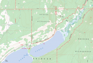
Located on the northeast shore of Lower New Fork Lake, this trailhead offers a moderate size parking area and corrals for stock users. Access to the Bridger Wilderness is provided by the New Fork Canyon Trail and the Doubletop Moutntain Trail.
Like our content?
Then you’ll love our newsletter.
New horse camps and trailheads, gear reviews, tips, videos, inspiring stories and more.


