Horse Trails
Horse Trails
Cole Creek Trails - 1trailmeister added this area
Waynesville, MO
Riders have logged 30.00 miles & 8.25 hours here.
TOP TRAIL RIDER: breezy logged 24.00 miles.
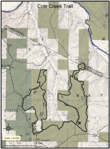
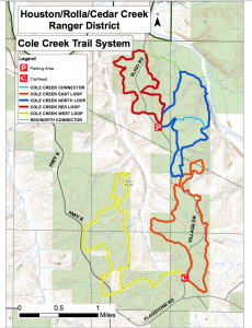
 Printable Map
-
 Directions
×
Directions
×Driving Directions
Click the icon for directions in google.From Waynesville, MO on Interstate 44, turn south at Hazelgreen onto Hwy AB. Take the frist gravel road to the right to Hwy K; travel about 6 miles south to the junction with Hwy AC. Turn east on Flagstone Road and travel about 2 miles and turn north on first gravel road. Trailhead is about 1/4 mile on the right.
-

- ★★★★★
 Printable Map
-
 Directions
×
Directions
×Driving Directions
Click the icon for directions in google.From Waynesville, MO on Interstate 44, turn south at Hazelgreen onto Hwy AB. Take the frist gravel road to the right to Hwy K; travel about 6 miles south to the junction with Hwy AC. Turn east on Flagstone Road and travel about 2 miles and turn north on first gravel road. Trailhead is about 1/4 mile on the right.
- ★★★★★
Rides Add Your Ride
| Date | Rider | Hours | Minutes | Miles | GPS | Photos | Rating | |
|---|---|---|---|---|---|---|---|---|
| 01 Dec 2020 | 1trailmeister | Ride Notes | 2 h | 0m | 6 | ★★★★★ | ||
| 02 Nov 2017 | breezy | Ride Notes | 3 h | 0m | 11.5 | ★★★★★ | ||
| 21 Oct 2017 | breezy | Ride Notes | 3 h | 15m | 12.5 | ★★★★★ |
The Cole Creek trail offers horse riders and horse campers a great chance to explore the Ozark hill country.
Land manager is Mark Twain National Forest – http://www.fs.usda.gov/recarea/mtnf/recreation/recarea/?recid=21806&actid=104
Like our content?
Then you’ll love our newsletter.
New horse camps and trailheads, gear reviews, tips, videos, inspiring stories and more.


