Horse Trails
Horse Trails
chuck swan wma - sugar4806 added this area
Sharps Chapel, TN
 Printable Map
-
 Directions
×
Directions
×Driving Directions
Click the icon for directions in google.Take I-75 N, to exit 112, Emory Rd and head east towards Halls. Go 5.1 miles and turn left onto TN-33 N/Maynardville Pike. Travel 23.4 miles and turn left onto Sharp Chapel Rd which will dead-end at the WMA.
-

- ☆☆☆☆☆
 Printable Map
-
 Directions
×
Directions
×Driving Directions
Click the icon for directions in google.Take I-75 N, to exit 112, Emory Rd and head east towards Halls. Go 5.1 miles and turn left onto TN-33 N/Maynardville Pike. Travel 23.4 miles and turn left onto Sharp Chapel Rd which will dead-end at the WMA.
- ☆☆☆☆☆
No Rides Found Be the first to Add Your Ride
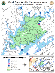
One of the most underused forests in East Tennessee are the 25,000 acres that comprise the Chuck Swan Wildlife Management Area. This scenic peninsula between the Powell and Clinch River on the eastern shores of Norris Lake, features miles of gravel roads to explore. Equestrians and a few mountain bikers are the more popular trail users. There are numerous roads that loop off the Main Forest road with additional spurs that head down to the lake and picnic areas. The century-old Mount Olive Baptist church and several old cemeteries, some dating to the early 1800’s (Lost Cr. Cemetery) are highlights of the area. The major roads are named and marked at intersections. Most of the loops are fairly level, although the Big Spring/Oaks Chapel loop has some steep sections. Jointly managed by TWRA and the Tennessee Division of Forestry, the area is seasonally open to hunting so be sure and check TWRA’s hunting schedule before venturing out into the woods.
Land manager is Tennessee Wildlife Resources Agency – http://www.tn.gov/twra/
Like our content?
Then you’ll love our newsletter.
New horse camps and trailheads, gear reviews, tips, videos, inspiring stories and more.


