Horse Trails
Horse Trails
Blue Ridge Horse Trail - 1trailmeister added this area
Winona, MO
 Printable Map
-
 Directions
×
Directions
×Driving Directions
Click the icon for directions in google.Located on Forest Road 3241 (called Flat Pond Road) off of Forest Road 3174 (called High Tower Road) and State Highway 19. Forest Road 3174 at Highway 19 is located approximately 12 miles south of Winona, Missouri or 15 miles north of Alton, Missouri on Highway 19. The easiest way to locate the trailhead is to follow the horse trail signs on the Flat Pond and High Tower Roads.
-

- ☆☆☆☆☆
 Printable Map
-
 Directions
×
Directions
×Driving Directions
Click the icon for directions in google.Located on Forest Road 3241 (called Flat Pond Road) off of Forest Road 3174 (called High Tower Road) and State Highway 19. Forest Road 3174 at Highway 19 is located approximately 12 miles south of Winona, Missouri or 15 miles north of Alton, Missouri on Highway 19. The easiest way to locate the trailhead is to follow the horse trail signs on the Flat Pond and High Tower Roads.
- ☆☆☆☆☆
No Rides Found Be the first to Add Your Ride
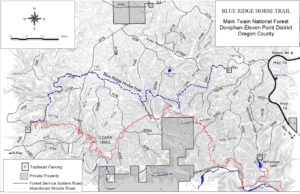
The Blue Ridge Trail is about 14 miles long. Additional miles may be ridden on a portion of the Ozark Trail. The total trail distance when using the Ozark Trail loop is 22.5 miles.
Like our content?
Then you’ll love our newsletter.
New horse camps and trailheads, gear reviews, tips, videos, inspiring stories and more.


