Horse Trails
Horse Trails
Andrews Creek Trailhead - 1trailmeister added this area
Winthrop, WA
-
 Directions
×
Directions
×Driving Directions
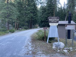
Click the icon for directions in google.From Winthrop travel on State Route 20 turning right onto Okanogan Country Road 1213 (West Chewuch Road). Drive 6 miles where county road joins with Forest Service Road 51. Drive for 22 miles to the end of the paved road then turn left for parking at the Andrews Creek Stock Use Trailhead immediately after crossing the bridge
-

- ☆☆☆☆☆
-
 Directions
×
Directions
×Driving Directions
Click the icon for directions in google.From Winthrop travel on State Route 20 turning right onto Okanogan Country Road 1213 (West Chewuch Road). Drive 6 miles where county road joins with Forest Service Road 51. Drive for 22 miles to the end of the paved road then turn left for parking at the Andrews Creek Stock Use Trailhead immediately after crossing the bridge
- ☆☆☆☆☆
No Rides Found Be the first to Add Your Ride
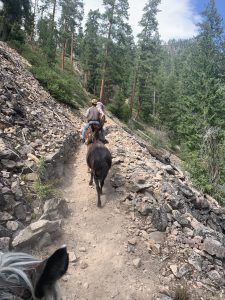
The Andrews Creek Trailhead outside of Winthrop, WA offers access into the Pasayten Wilderness through the Andrews Creek drainage. At the trailhead riders will find ample parking for trailers as well as hitch rails. The corrals are in an advanced state of decay and are not safe for use. Highline-able trees are scattered through the area. A vault toilet is located across the road in the hiker’s parking area. Stock water can be sourced nearby in Andrews Creek.
Andrews Creek trail (504) is 16 miles long and runs from the trailhead to the Spanish Camp patrol cabin where it intersects with the Boundary Trail (510). The entirety of the trail has been impacted by the 2003 Fawn Creek Complex fire.
Fee area – A recreation pass is required
Certified weed free feed is required
Like our content?
Then you’ll love our newsletter.
New horse camps and trailheads, gear reviews, tips, videos, inspiring stories and more.


