Horse Trails
Horse Trails
Bryce National Park - cfurse added this area
Panguitch, UT
-
 Directions
×
Directions
×Driving Directions
Click the icon for directions in google.From Panguitch, Utah, follow signs towards Bryce Canyon. There is no horse camping in Bryce. Nearby Camping is available at: Coyote Hollow Equestrian Campground - https://www.trailmeister.com/trails/coyote-hollow-equestrian-campground/ Nearby Dry/Primitive Camping is available at: A variety of BLM dirt roads are due west of the Losee and Casto Canyon trail heads. These are unmaintained, rough, single-track dirt roads suitable for rigs with high clearance and small to moderate turning radius. Not suitable for lower, larger rigs. There are no official camping sites, but several places people have typically camped. Do not camp in the outfitter turn around (where there is a corral... its for the outfitter, not private parties). There are also a few areas (2-3?) people have camped on either side of the road between Losee and Casto Canyons. Maps: You can get detailed maps of the area at the Red Canyon Visitors Center https://utah.com/bryce-canyon-national-park/red-canyon * Bryce Canyon & Brian Head Trail Map (www.AdventureMaps.Net) * Dixie National Forest Powell Ranger District Travel Map (US Forest Service)
-

- ☆☆☆☆☆
-
 Directions
×
Directions
×Driving Directions
Click the icon for directions in google.From Panguitch, Utah, follow signs towards Bryce Canyon. There is no horse camping in Bryce. Nearby Camping is available at: Coyote Hollow Equestrian Campground - https://www.trailmeister.com/trails/coyote-hollow-equestrian-campground/ Nearby Dry/Primitive Camping is available at: A variety of BLM dirt roads are due west of the Losee and Casto Canyon trail heads. These are unmaintained, rough, single-track dirt roads suitable for rigs with high clearance and small to moderate turning radius. Not suitable for lower, larger rigs. There are no official camping sites, but several places people have typically camped. Do not camp in the outfitter turn around (where there is a corral... its for the outfitter, not private parties). There are also a few areas (2-3?) people have camped on either side of the road between Losee and Casto Canyons. Maps: You can get detailed maps of the area at the Red Canyon Visitors Center https://utah.com/bryce-canyon-national-park/red-canyon * Bryce Canyon & Brian Head Trail Map (www.AdventureMaps.Net) * Dixie National Forest Powell Ranger District Travel Map (US Forest Service)
- ☆☆☆☆☆
No Rides Found Be the first to Add Your Ride
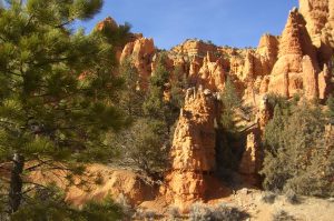
Bryce Canyon and the surrounding area are stunningly beautiful to ride. Red rock and hoodoos abound, as well as extensive areas of aspen, bristle cone pine, and a variety of wild flowers.
Bryce Canyon, Losee-Casto Canyons and Thunder Mountain are definitely “bucket list” rides with amazing red rock vistas.
You can rent horses/mules for a ride into Bryce (and nearby trails), or you can bring your own. To ride your own horse into Bryce Canyon (Peek-a-Boo loop), you will need to make a reservation for a specific time (times are available in early morning, noon, late afternoon) at least 24 hours in advance, pay the fee to enter Bryce, and meet a ranger to check your travel papers near the gate. Riding the loop is in one designated direction so that you don’t run onto an outfitter\’s string head on in a narrow place (yay! it works well). Detailed instructions are at the Bryce Canyon link below.
The National Park Service is the land manager for Bryce Canyon: https://www.nps.gov/brca/planyourvisit/trailrides.htm
Like our content?
Then you’ll love our newsletter.
New horse camps and trailheads, gear reviews, tips, videos, inspiring stories and more.


